

Getting Around
Navigating the city of Atlanta can be achived in a few ways. The city is home to 47.6 miles of heavy rail, 91 bus transit routes, 1600 licensed taxis, a comprehensive network of freeways, the world's busiest airport and over 45 miles of bike paths.
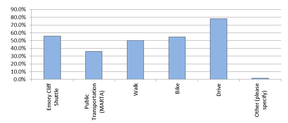
How Do Rollins Students Commute?
The chart below illustrates the results of a survey we recently offered to current students about their communting choices. Most students drive to school while others take greener options such as the Emory Cliff shuttle and Atlanta’s public transportation system, MARTA.
Local Transportation Options
MARTA (Metropolitan Atlanta Rapid Transit Authority) is the primary public transportation system in Atlanta.
- Serves about 500,000 riders per day
- Bus Route 6 serves the immediate Emory area and surrounding neighborhoods
- Lindbergh Train Station is the closet rail stop to Emory. You would then transfer at that station to Bus 6 to get directly to the campus
- MARTA is an effective mode of transportation if you live in or around the Emory area. It is also good to use if you will be going to the airport, attending sporting games, festivals, concerts, etc. in the downtown/midtown area. Parking at these events and traffic tend to be a challenge.
- The University's structured sytem of transportation options
- Includes vanpools, carpools, ride shares and more
- Discounts and incentives are available; organizations work in tandem with Emory to improve transportation to and from campus
Other Transit Options
- Access to other areas of the city
- Car Share through ZipCar
- Buckhead: FREE ride on Buckhead's fast, free shuttle service, the Buc Ride. You can ride between the popular Lenox Square and Phipps Plaza, a variety of great restaurants, and office complexes.
- Cobb Community Transit provides transportation within Cobb County, including destinations such as Town Center Mall and Kennesaw State University.
- Gwinnett County Transit services such popular destinations as Discover Mills Mall and Buford Highway, north of Atlanta.
Biking Resources
Downtown/Midtown Area Map from Atlanta Bicycle Coalition
GoogleMaps for Biking: